Showing posts with label George Bush Park. Show all posts

Wednesday, February 22, 2017

Text When George Bush Park Flooded Needs Adjusting

I have previously written about one of my favorite bike commuting tools the USGS SMS Update when George Bush Park is flooded.   Unfortunately this tool no longer seems to be effective.  The Army Corps of Engineers is strengthening the dam and moving the current water gate and this looks to have effected the USGS sensors in the dam.  From September through November 2016 the USGS wasn't even providing text updates.  The service has resumed but the park was flooded this morning at just over 82'.  In the past the park was always passable up to 84'.  So I am thinking I may need to change my SMS alert to anytime the water level is above 80'.  I'll keep playing with it and please let me know what you are finding

Flooded George Bush Park
Hard to see in the dark but this is looking East towards Barker Cyrpress after passing the wood boardwalk.  The path is flooded


George Bush PArk Flooded at just over 82'

Saturday, June 18, 2016

Pictures: George Bush Park Still Flooded

George Bush Park has been flooded since April 18th.  Today's June 18th email alert from the USGS has the Barker reservoir at 90.87 feet and it needs to get to 84' to be passable.  In the past when the park has flooded it seemed like the park lost about .50-.75" of water per day.  If that is true we are six to eight days from being able to ride through the park again.  If we get no more rain- please please please!

USGS Chart of elevation of reservoir water at Barker Reservoir

I decided to check out the park and see what it looked like after being under water for two months.  Below are the pictures of my ride.  I entered the park from the FFPS soccer fields on the West side of the park. I've never seen it this flooded and, unless a lot water is let out from the reservoir, I have a hard time seeing the path clear for weeks.  Again, everything is conditional on NO MORE RAIN!
Warning side as soon as you enter the multi-use trail from the bridge that leads to the FFPS soccer fields


Friday, June 26, 2015

New Commute, The Good, Bad, & Ugly

I'm now commuting from Katy to an office building on the North I-10 frontage road and Kirkwood.  It's 19.5 miles each way and in many ways encompasses the best and worst of bike commuting in Houston.  With the shared use paths on the Bayous,George Bush & Terry Hershey parks, roughly 18 of the 19.5 mile commute is car free and safe as can be.  It's a scenic ride where I've seen deer, armadillo, rabbits, squirrels, alligators, coyotes, opossum, snakes, cygnets, swans, vultures, hawks, ducks, etc.  18 really great commuting miles.

Route Using Kirkwood Heading North
The other 1.5 miles or so isn't as great.  If I take Terry Hershey East to Kirkwood (screen shot above) I then travel North on the Kirkwood "bike lane".  This designated bike lane is maybe two feet wide and usually filled with debris.  The painted lane is faded and almost nonexistent in many spots.  It's the type of bike lane that is more dangerous than good.

Commute Using Terry Hershey Park  North of I-10

If I take Terry Hershey North of the I-10 (screen shot above), I ride on the sidewalk of the I-10 frontage road like a dork.  In the morning I'm going against traffic and in the evening constantly looking over my shoulder to make sure I don't get slammed by a right turning car.  I then cut up Eldridge for a block, again dorking it on the sidewalk, to get to Dairy Ashford and another 2 foot bike lane, albeit with less debris than Kirkwood.  This bike lane takes me to another off street shared use path at the Addicks Reservoir.  The weird thing is that heading East on Dairy Ashford there is no way to make a proper left turn onto the shared use path.  They built this great path and then also put a concrete median in the middle of Dairy Ashford blocking the path from East bound riders.  I end up riding in the painted median, cutting across Dairy Ashford and riding in the gutter against traffic for maybe 50 yards before I can make a left onto the path.  In the evening going home heading West the cars lining up to go right on Eldridge end up pinching the 2 foot bike lane.  I haven't clipped a side mirror yet but it won't surprise me when I do.

Map of Energy Corridor paths found on Addick Reservoir bike path.  North is the bottom of this map

Start of shared use path at Addicks Reservoir just off Dairy Ashford.  I need to take a photo of the jacked up median on Dairy Ashford that blocks this entrance

North I-10 frontage road facing East just after exiting Terry Hershey Park

Start of Terry Hershey Park North of I-10

Thought the Texas flags were a nice touch on this day.  This is the path around the Barker Reservoir that takes you towards George Bush Park.
I've seen riders on the street of the I-10 frontage road, and they have my respect, but I just don't feel comfortable sharing the road with that heavy car traffic.  Lately with all the rain George Bush Park has been flooded and I haven't been able to use the path.  I know I can take city streets to get to work, and in the morning sharing the roads isn't so bad, but in the evening when the roads are crowded and drivers are impatient...I just don't want to do it.  Four cyclist have been killed on our streets in the last month and that just chills me.  So there you have it.  A great workout, wonderful safe ride with beautiful scenery, and some frustratingly not well planned bike lanes on city streets.  And Mother Nature throws her twists in as well.

Friday, May 1, 2015

Update Tool When George Bush Park Flooded

***Update February 22, 20017.  The shared use path through George Bush Park is flooded this morning while the water level is 82'.  I'm not sure if the ongoing Army Corps of Engineers work has changed the USGS sensors or what but the below info needs to be updated-- see here:

http://cyclingspacecity.blogspot.com/2017/02/text-when-george-bush-park-flooded.html?_sm_au_=icVqSQJ24nJv1q2P  *****

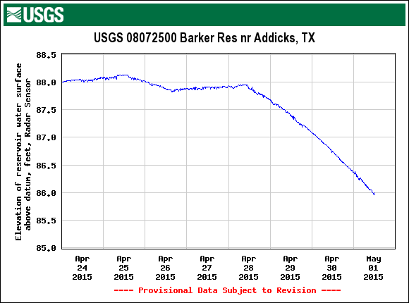
A coworker introduced me to this great tool from the United States Geological Society that notifies you when the path at George Bush Park is flooded.  He claims when this chart of the elevation of Barker Reservoir is above 84 inches feet the path is flooded.


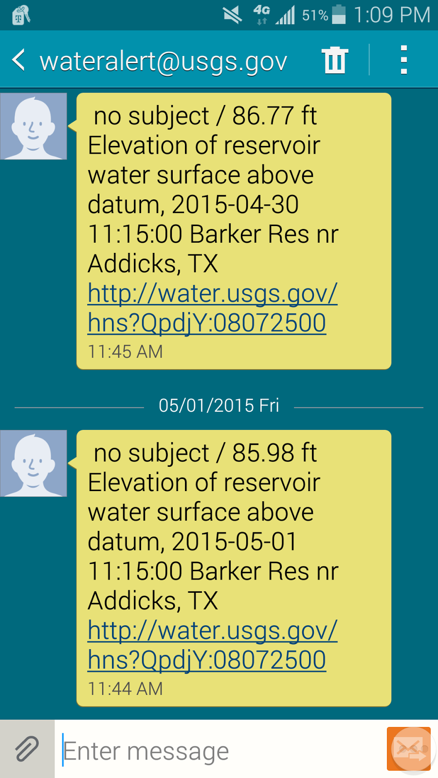
You can set an SMS alert to send a daily update when the water level is above a certain thresh hold, in this case 84 '.

I know the park was flooded yesterday April 30th and if the trend line continues the park should be okay for a Monday commute.  I'm looking forward to seeing how accurate this is.  Twice last year I packed the panniers and headed out for work to find the park was surprisingly still flooded and return home for a cager commute.

You can find the graph, and sign up for the alerts, here waterdata.usgs.gov  The chart you want is third down  "Elevation of reservoir water surface above datum, feet, Press Transducer, High Orifice"

Monday, April 6, 2015

Road Rage On The Bike Path

So commuting by bike is supposed to be my healthy alternative to the madness that is commuting by car in Houston, but tonight I got in a bit of a row on my commute home.  This happened where the shared use path around Barker Reservoir ends at Sergeant Hatch Park.   You know where people who drive their cars, to go ride their bikes, end up parking.  So I am coming upon the exit of the path and there is another rider approaching from the other side to enter the path.  There is only room for one bicyclist at a time to pass.  So who has right of way when two cyclists are approaching at nearly the same time?

My first rule is if there is a brutal wind whoever is eating the 20-30 mph headwinds has my respect and the right of way.  Barring that I think it should be the person exiting.  Here is my reasoning:

1) Do you barge onto the elevator when the doors open and before people have a chance to get off?
2) In this case I was in the middle of my ride/commute and the other rider hadn't even started his ride, he can wait.
3) I'm riding with fully loaded panniers on each side of the bike.  Cut a guy some slack.
4) But mostly his ride hadn't even started.  Let the other rider exit the path and then go!

So as I approach the exit the other rider makes no assertive move or clear intention that he thinks he has the right of way.  He was kind of paused before the gate and I decided he was waiting for me and I made my move.  As I passed through the gate we came close to each other and he looked uncomfortable, I almost think he was having trouble getting in and out of his clips, and loudly called me an "idiot".  I didn't take to this at all.  I stopped my bike dropped a "F You" back to him, invited him to stop, turned my bike around and went through the gate, re-invited him to stop, and called him a spiteful woman with a 5 letter word but he kept riding away. Of course I am going to keep my eyes out for Mr new bike, new kit, can't get in his clips, drive to go ride his bike, shit talker.  I got a couple ideas for him.

Then a couple miles into George Bush Park I saw a young girl getting helped to the trail parking area.  It looked like someone was calling her an ambulance.  From the way they were immobilizing her arm at the elbow I think she had a broken collarbone.  Just a nasty injury.  I feel terrible for her.  I want people out on the shared use paths enjoying their bikes.  I guess in retrospect I'm glad the "idiot" caller didn't take me up on my offer.  We should be having fun out there folks!

Friday, March 27, 2015

Church on Barker-Clodine Getting Moved

So I rode through George Bush park today and was surprised it wasn't flooded.  The ride started out great.  I saw two deer.  I haven't seen deer in the park in a longtime but came across two young deer.  They were thinking about crossing the shared path but were unsure about me and ran back into the bushes.  Then on Barker-Clodine Rd I saw they are now moving the old church.  First it was the old Barker Store and now the Church.  I would love to know where they are going to and what is going in their spot.  Just across from the site the store and church were on is a development of new apartments.  I'm wondering if they are expanding the apartments into the area the old buildings sat on.


Tuesday, February 24, 2015

What happened to the Barker Store & Post Office?


So an incredible Saturday found me hung over on Sunday and in no condition to challenge personal records on Strava.  I still needed to get out and get some time on the bike.  So I rode through George Bush Park, around the reservoir, to where Highway 6 and Terry Hershey Park meet.  I decided I would make frequent stops and enjoy the park.  Usually my rides on this route are a hurried commute or a test of how fast I can ride.  It had been two years since I actually rode through the park to appreciate the park. Damn if I didn't miss a major change. 

On Barker-Clodine Rd as you exit the park to the North there is an old church.  Next to the church stood the Barker General Store and Post Office established in 1898.  I loved that this old building was still standing.  Clearly it has moved from its original location on Barker St but that was great.  Someone in Houston gave a shit.  Someone cared enough to preserve this old piece of history.  Well it’s gone now.  I have been banging away at Google but can’t seem to find anything about a planned relocation.  Good god don’t tell me this building became firewood.  Between this building disappearing and no-one seeming to give a shit that TXDOT has a plan to destroy the bike path through the park, I don’t think I can take much more.  

A coworker said he saw the building being put on a truck for moving.  Can anyone confirm this or where it went?  Here is an article about Barker, TX and some pictures I took of the building a couple years ago.


Friday, February 13, 2015

Proposed Road To Cut Through George Bush Park

Last night another cyclist told me that the Texas Department of Transportation (TXDOT)  has approved a road connecting Highland Knolls Dr. with Briar Forrest Dr.  This new major thoroughfare would cut right through the North section of George Bush Park and effectively kill off a green space area and a multi-use path used by thousands of joggers, walkers, and cyclist every month.

I'm still trying to get more details but this article gives some info.  The proposal is part of the West Houston Mobility Plan (link to plan) from the Galveston-Houston Area Council (whatever the hell that is).  This plan was finalized December 18th with the expectation that TXDOT will approve it this month.  What that means for actually getting built, I have no idea.  This is a terrible plan.  There are already 4 East-West thoroughfares through the area: 1-10, I-10 frontage road, Westheimer Pkwy, West Park Tollway.  I believe this new route would cut through a reservoir, mess up the regional flood protection, and kill of a major cycling route.

Here is a map of the recommended changes.  If my color blind eyes are reading this right, it shows existing streets connecting Kingsland Blvd with Memorial and Barker Cypress running through the park.  Hard to have faith in this study with such major errors.


My best hope right now is that this is some study that gets approved and then sits on a shelf for years without ever getting implemented.

Monday, February 9, 2015

Scoping New Work Commute Routes

So I have a new job that will have me working at Enclave Parkway near Briar Forrest in the Energy Corridor for the next 2 months.  I decided to try out possible routes from Katy on a Sunday afternoon.

Scoping Out New Work Commute Routes

With the multi-use path through George Bush Park and Terry Hershey Park I can ride most of the roughly 16 miles car free.  I was hoping there would be an exit from Terry Hershey right next to my new office but there wasn't.  If I exit at Enclave Parkway it is a fairly short ride to Briar Forrest Rd and there is a bike lane.  Always a welcome sight to see a bike lane

Bike Lane on Enclave Parkway

The shortest and quickest route is to skip Terry Hershey and instead take Briar Forrest from the end of George Bush park.  Unfortunately the bike lane on Briar Forrest has a lot of debris and sections where construction has blocked the path.  As nice as it is to see a bike lane, sometimes in Houston they can be pretty impractical.  So my choices are the winding , and in the early evening crowded with joggers, dog walkers, families, etc Terry Hershey path, and Briar Forrest with its less than stellar bike path and rush hour cars.  Guess that will be a game time decision.  Either way I am looking forward to commuting via bike again.

Wednesday, May 14, 2014

Flooded Out Bike Path For Bike To Work Day

In 2013 I commuted a tad over one-thousand miles via bike.  Four things kept me from commuting more: business trips, work from home days, lightning, and flooding. So far in 2014 I have commuted just over a hundred miles by bike because I'm now a full-time teleworker.  So I was really looking forward to May 15th's Bike To Work Day.  I used the day as a reason to schedule meetings in the office and made plans to meet up and commute with a fellow Katy dwelling coworker and MS 150 teammate.  So of course we get 8 inches of rain the last two days and the path through George Bush Park is flooded out the night before Bike To Work Day.  Unfortunately the only alternate routes I know of involve streets with heavy car commuter traffic.  Next year then! 

Check out these pictures I took of the mixed use path through George Bush Park on May 14th at around 7:00 PM.

George Bush Park, Houston, Flooding
Bench that looks over the river that runs through the park.  This is west of the boardwalk

George Bush Park, Houston, Flooding
Entrance to boardwalk from west side

George Bush Park, Houston, Flooding
Heading East towards Barker Cypress just after the boardwalk

George Bush Park, Houston, Flooding
Heading East towards Barker Cypress just after the boardwalk


Friday, May 2, 2014

Energy Corridor Bike To Work Site


In advance of May 15th's Bike To Work Day I came across the Energy Corridor District's great Bike To Work site.  They are having an event on Bike To Work Day from 6:30 to 7:30 AM at the Gazebo, just off Memorial, in Terry Hershey park featuring a free breakfast, raffle, and giveaways.  They will have Bike Champions leading commutes from several points in the surrounding area (Alief, Heights, Sugarland, Katy) into the event at Terry Hershey. The longest commute I saw was 19 miles. You can sign up for a ride or email a champion for more info.  These route maps are a keeper. 

My commute from Katy is pretty close to one they are doing, though I add a mixed use path from Fry & Mason to Westheimer instead of proceeding further North on Fry.  I just like being off the roads especially during commute hours.

These route maps are a keeper for both commuting and weekend ride ideas..

Bike commuting routes in Houston Texas

Bike Commute Route in Houston Texas

Bike Commute Route in Houston Texas

Bike Commute Route in Houston Texas

Bike Commute Route in Houston Texas

Bike Commute Route in Houston Texas

Bike Commute Route in Houston Texas


Bike Commute Route in Houston Texas


Thursday, February 20, 2014

Personal Best Commute Time & Fans Welcoming Sagan To Cali (Video)

Stoked to drop over four minutes from my personal best on my commute this morning!  And I have to share this great video from the Amgen Tour Of California folks.  It is Peter Sagan meeting his fans.  Check it out.

This mornings bike commute to work


Friday, February 14, 2014

Let The Commute Begin

Houston Bicycle Commuting:

Coming soon I'll go into greater detail on my commute and commuting in Houston but for now a short trip report.  Between the short days, ice storms, and crazy work schedule I haven't commuted via bike once this year.  So it felt great to get up a little early this morning and get on the road.  It was about 45F and foggy.  Around the Barker Cypress Reservoir was extremely foggy and seven miles into my seventeen mile ride my toes started to get numb, but other than that it was perfect.  I saw three other cyclists and a couple joggers going through George Bush Park, which is light traffic for this heavily used trail.  Perhaps it's still a little early and cold for the masses to start taking advantage of the park. One of my favorite parts of riding through the park early in the morning, or just before dusk, this time of year is seeing deer roaming the park.  

Bike commuting through George Bush Park, Houston. TX. Strava segment "GBP Heading North",
This would be Strava segment, "GBP Heading North"
Bike commuting through George Bush Park, Houston. TX, Strave section "ILC Sprint"
Start of Strava section "ILC Sprint"

bike commuting through George Bush Park, Houston. TX. Start of Strava section George Bush East Police Substation to Hwy 6 Curve
Start of Strava section George Bush East Police Substation to Hwy 6 Curve

Bike commuting through George Bush Park, Houston. TX. Rounding around the North side of Barker Cypress heading East.
Rounding around the North side of Barker Cypress heading East.